A different way to ask where the center is
Washington, DC is usually described through neighborhoods, quadrants, wards, planning areas, or the symbolic axis of the National Mall. Each is useful, but none directly answers a physical question: where do building coverage and height combine to form one continuous concentration of structurally intense urban development?
The Structural Core answers that question without beginning from familiar place names. It is derived from the city’s built fabric first. Names and interpretations are applied only after the connected geography has been measured.
How the Structural Core is measured
Structural Intensity combines two characteristics of every native raster cell: estimated building-footprint coverage and normalized building height. Cells at or above the fixed Structural Intensity threshold of 0.007987 qualify for the connectivity analysis.
Qualifying cells are connected only when they touch along an edge or at a corner—the strict eight-neighbor rule. There is no smoothing, manual bridging, or gap filling. The largest connected qualifying component within Washington, DC’s municipal boundary is designated the Structural Core.
What the Washington, DC analysis shows
The result is one Structural Core covering 5.397 square miles, or 13.978 square kilometers. It lies primarily north of the National Mall and contains the District’s geographic center near 4th and L Streets NW.
The National Mall is therefore neither the geographic center nor the structural center of the District. Its monumental open space and surrounding institutional geography create a major interruption between the Structural Core and L’Enfant Plaza–Southwest Waterfront to the south. Navy Yard–Capitol Riverfront remains separate partly because of below-threshold rowhouse fabric southeast of the National Mall.
Planning integration, accessibility, public-realm continuity, edge activation, and internal reinforcement can improve materially while strict raster-based structural separation persists.
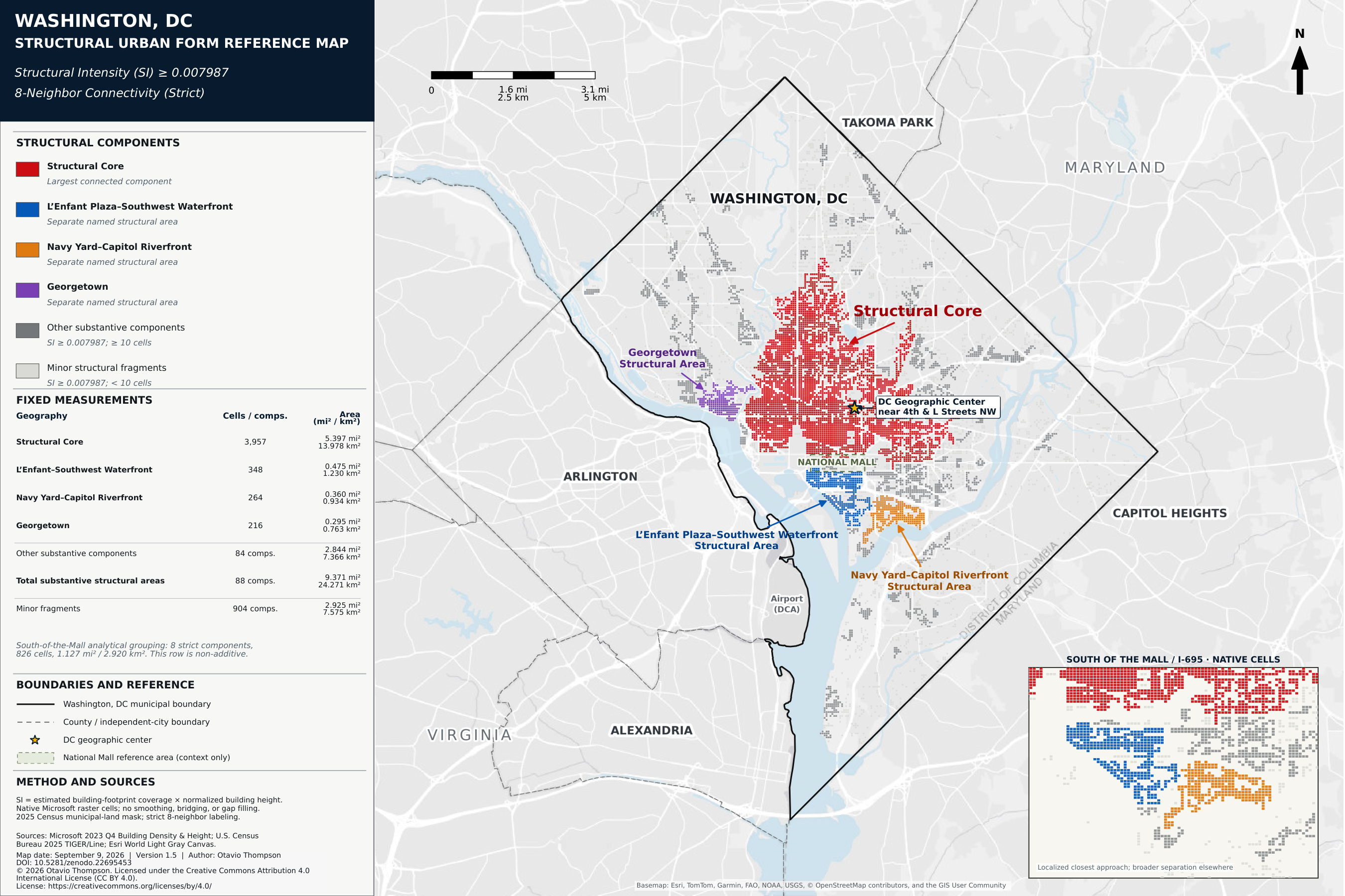
Source: Otavio Thompson, Washington, DC Structural Urban Form Reference Map, Version 1.5 (September 9, 2026). © 2026 Otavio Thompson. Licensed under CC BY 4.0.
The city remains structurally polycentric
South of the Mall, eight disconnected substantive components cover 1.128 square miles, or 2.920 square kilometers. The two largest named areas are L’Enfant Plaza–Southwest Waterfront and Navy Yard–Capitol Riverfront. Georgetown forms another separate structural area west of the Structural Core.
These separations do not all have the same cause. The Mall interrupts the connection to Southwest. Historic rowhouse fabric and other below-threshold cells help separate Navy Yard–Capitol Riverfront. Georgetown’s separation reflects a different physical relationship to the Structural Core. The map therefore shows a hierarchy of connected and disconnected concentrations, not one undifferentiated downtown mass.
What the finding does—and does not—mean
Structural separation is not the same as social, economic, or transportation isolation. People and activity move across the boundaries identified by the raster analysis. The method measures the continuity of built form, not every relationship that makes a city function.
That limitation is also the measure’s value. By holding the structural layer steady, the result can be compared with neighborhoods, transit, land use, population, and economic activity without allowing any of those systems to define the answer in advance. Washington, DC emerges as a city with one Structural Core and several substantial, physically distinct concentrations.